River Valley News - May 9/24

Edmonton and Strathcona 1912 merger created street names uproar

The merger of Edmonton and Strathcona in 1912 created a huge amount of confusion. Dozens of street names were duplicated on either side of the river. The new city was also in a development boom and developers created street names to market their neighbourhoods, to advertise prominent businesses, even to honour members of their families.

Mayor William Short and city council decided to act unilaterally and without public consultation, introduced the numbered street system that we use today. In 1913, the City started tearing down its named street signs and installing standardized number signs instead. The backlash was instantaneous and later in 1913 Mayor Short was voted out of office, the first time an incumbent mayor had lost an election in Edmonton’s history.

Public discontent led to an April 6, 1914, plebiscite which asked, “Which do you favor: The all-numerical scheme of 1913 whereby large numbers are in the centre of the city, or The scheme of Edmonscona, partly numerical and partly names, and giving small numbers in the two centres of the city, one on each side of the river.” In the end Mayor Short’s 1913 plan won by six hundred votes.

Despite the plebiscite’s results, criticism of the 1913 Plan persisted. “People can’t remember these big numbers,” said Alderman Joseph Henri Picard in 1915. “I know I cannot, for I can’t even tell where the streetcars are going. We don’t want to be given numbers like convicts who have no reason to be known by their names.” https://citymuseumedmonton.ca/2016/03/15/the-edmonscona-plan/

Health benefits of nature

Nature protects drinking water, filtering pollutants, purifying the air, and moderating our climate. Tree loss in communities correlates with increased mortality from cardiovascular and lower respiratory diseases. Elderly people are more likely to get the recommended 2.5 hours of weekly walking when they have access to green space.

Interactions with nature can lower blood pressure, reduce depression and feelings of fear, anger or aggression. Spending time in green spaces allows people to think more clearly. Children exposed to nature at a younger age develop better immune systems and have reduced rates of asthma. For every 350 trees per square km, asthma rates can drop by as much as 25% in young children.

When we lose nature, and the plant and animal diversity it houses, we lose opportunities to discover new medicines. Some of the medical treatments discovered in nature include Aspirin from willows, and Taxol, used in chemotherapy for a range of cancers, from the Pacific Yew tree. https://static1.squarespace.com/static/569ec99b841abaccb7c7e74c/t/5e6bca8e810aeb772521f2bd/1584122514485/Health+Benefits+-+Updated+2020.pdf

Alberta Indigenous boats

First Nations’ boats on the plains were often made of buffalo hides stretched over willow or pine frames. This bull boat was a small, circular craft quickly built from tipi hides and recycled shortly after. It enabled safe river crossings but wasn’t designed for long trips. Like tipis, bull boats were traditionally the property of women who built and paddled them.

In the boreal forest, rivers are often the only relief from dense trees or muskeg and here a niche was carved for dugout canoes. Dugouts were formed by chipping soaked or partially burned logs with stone axes. The final gouging was done with a clever tool borrowed from nature’s furry carpenters: beaver teeth.

Early boat builders used chisels made of beaver incisors tied to wooden handles. With use, beaver tooth dentine is worn away, which exposes new sharp enamel ridges. The result is a self-sharpening chisel that was used by Cree and Dene across the boreal forest.

The birch bark canoe was made of sheets moulded into place then sewn together with tree roots. Holes were glued shut with sap or, in Northeast Alberta, bitumen. Great skill was needed to harvest the right bark, steam the sheets, and bend the frames. The birch bark canoe turned endless tendrils of water into interconnected arteries of movement.

It expanded social networks, was a conduit for information, and opened new worlds to exploitation. People used canoes to hunt big game at water crossings and to set fish nets. Torches mounted on the ends of canoes at night attracted fish for spearing. And when game failed, people could move long distances to find relief. https://albertashistoricplaces.com/2015/08/12/birch-bark-buccaneers-and-prairie-paddlers-an-illustrated-look-at-albertas-early-boating-part-1/

Riparian areas critical to many species

Mike writes “I want to add a comment that relates to two of the items in the newsletter. The area of the proposed YEG national urban park includes some of the last intact riparian wetland areas left in Edmonton. The oxbows and semi-permanent wetlands around Big Island, and in the "Bigger Island/Snake Valley" region of the proposed park provide natural habitat for amphibians, dragonflies, and several species of songbird that have largely been driven out of the more developed parks, golf courses, neighborhoods, and former landfills that sit alongside the river through the rest of the city. Conservation of these wetlands should be a priority for all levels of government.”

South LRT monuments by Aaron Paquette, Jason Carter, Chloe Mustooch. Art panels along the South LRT line https://www.edmontonarts.ca/public-art/south-lrt-monuments

Comment or Contributions

Please note articles may not reflect the position of NSRVCS. River Valley News is meant to be a clearinghouse for the variety of opinions and ideas about Edmonton’s River Valley.

Email river valley photos, event information, comments, or questions to nsrivervalley@gmail.com

Forward this link to anyone you think may want to sign up for this newsletter https://www.edmontonrivervalley.org/newsletter-signup

River Valley News - May 2/24

Province to set conditions for YEG national urban park

David Bajer photo

Bill 204, which recently passed in the legislature, grants the Alberta government more power over decisions around national urban parks. The bill states that the province can prescribe conditions under which a municipal council may negotiate a proposed national urban park plan and councils would be required to follow those conditions. 

In 2021, the federal government launched the National Urban Parks program to create parks in urban centres. The City of Edmonton and Parks Canada entered into a formal agreement to explore the possibility of creating a national urban park in the river valley in 2022. 

In a written statement to CBC, Edmonton Mayor Amarjeet Sohi said the city will "never cede control of our cherished river valley to any other level of government, be it federal or provincial. This bill is another example of the province creating more red tape and getting in the way of the City of Edmonton working collaboratively with other levels of government and community stakeholders."

The Canadian Parks and Wilderness Society asked why the province would introduce roadblocks to the park creation process. "Albertans have made it abundantly clear that they love parks and want to see more, not fewer, parks," said Kecia Kerr, CPAWS northern Alberta's executive director.

https://www.cbc.ca/news/canada/edmonton/new-bill-allows-alberta-government-to-set-conditions-for-national-urban-park-decisions-1.7177597

Carbyn Creek Wildlands open for visitors

Edmonton and Area Land Trust has announced the opening of the Carbyn Creek Wildlands conservation site. It is in Westlock County, south of Cross Lake Provincial Park, a 1.5-hour drive from Edmonton. The wildlands are a protected breeding, nesting, and staging area for migratory and resident birds, and for research, education and nature appreciation.

A variety of bird species have been recorded during breeding bird surveys including Pileated Woodpecker, Broad-winged Hawk, and many songbirds such as the Black-and-White Warbler, Boreal Chickadee, and Blue-headed Vireo. This land also provides habitat for other species including moose, bear, and amphibians like the western toad.

The trails at Carbyn Creek Wildlands lead visitors through mature mixed woods forest and spruce bogs, with a view of the creek that winds its way through the boreal forest landscape. Lu Carbyn, a renowned biologist, donated the land in the hope it will provide incentive to protect surrounding lands in the area. A guided tour led by Lu, will take place on May 10 from 10am to 2pm. Register at https://www.ealt.ca/event-listing/carbyn-creek-walk

Is your neighbourhood vulnerable to climate change

Mack Male photo

University of Alberta researchers have used public data to create a set of maps that illustrate the Edmonton neighbourhoods where residents are most vulnerable to negative health outcomes caused by climate change.

The team found that much of the city’s south and west have more exposure to pollution and extreme weather, less natural protection, and more people who hail from vulnerable demographics. City areas and residents least vulnerable to climate change are around the university, downtown, Oliver (soon to be wîhkwêntôwin), Bonnie Doon, North Glenora, Spruce Avenue, Beverly, and Mill Woods Town Centre.

“These maps aren’t meant to stigmatize any particular areas, just because you might live in an area with higher vulnerability, we’re not saying you need to move,” said Sammy Lowe, research lead of UofA’s Climate, Health, and Environment Epidemiology Research lab. “Edmonton, in general, is doing well in the grand scheme of things in terms of climate health vulnerability. So even though some of these areas are a bit worse, they’re not necessarily doing terribly.”

When determining how vulnerable a neighbourhood is, the lab takes three domains into account: its risk of experiencing pollutants and extreme weather (exposure), its features that can mitigate those consequences of climate change (adaptability), and socioeconomic and demographic traits that can make its residents more susceptible (sensitivity). Those three factors combine to indicate a neighbourhood’s vulnerability.

https://edmonton.taproot.news/news/2024/04/24/is-your-neighbourhood-vulnerable-to-climate-change-new-research-provides-answers

Riparian areas critical to many species

Riparian areas are transition zones between terrestrial upland and aquatic ecosystems. They occur along waterbodies such as streams, lakes, rivers and wetlands, and are one of the most productive ecosystem types, supporting diverse flora and fauna including fish, invertebrates, reptiles, amphibians, birds, mammals, and plant communities.

These lands provide critical sheltering, rearing, feeding, and reproduction habitats for many species, some of which are not found anywhere else on the landscape. Its vegetation includes moisture loving sedges, rushes, shrubs, grasses and forbs, which slow the flow of water and allows water to seep into the soil, replenishing ground water reserves in the spring. In drier periods, ground water seeps back into streams to maintain stream flow.

Riparian vegetation acts as a filter for any sediments and chemical pollutants in run off. This is important, as excess nutrients going into waterbodies can result in algae blooms, depleting dissolved oxygen in water, and leading to high fish mortality.

Healthy, well functioning riparian lands are more resilient to environmental stresses and natural or human disturbances. They do not have many weeds since weeds colonize areas where disturbance has created bare soil. The presence of woody plants, like willows, in varied age classes is a sign of ecological stability. https://static1.squarespace.com/static/569ec99b841abaccb7c7e74c/t/5e6bcdbbb33b15147b2a83b1/1584123329394/Riparian+Areas+-+Updated+2020.pdf

What is this

Mark writes “The brick structure on the single-track trail below Keillor Road is likely an old coal mine entrance, similar to some along the river between Dawson Park and Rat creek.”

Tsa Tsa Ke K’e – Iron Foot Place by Alex Janvier, Rogers Place Arena - Ford Hall

https://www.edmontonarts.ca/public-art/tsa-tsa-ke-ke-iron-foot-place

Comment or Contributions

Please note articles may not reflect the position of NSRVCS. River Valley News is meant to be a clearinghouse for the variety of opinions and ideas about Edmonton’s River Valley.

Email river valley photos, event information, comments, or questions to nsrivervalley@gmail.com

Forward this link to anyone you think may want to sign up for this newsletter https://www.edmontonrivervalley.org/newsletter-signup

River Valley News - Apr 25/24

Edmonton has had 145 wildfires since January 1

Across Edmonton, there have been over 145 wildfires since January 1. These have occurred from the outskirts of the city and into our river valley, one of Edmonton’s most expansive assets that stretches across 7,300 hectares of urban forest. In the first two weeks of April, according to Fire Chief Joe Zatylny, anywhere from five to 10 grass wildfires were happening per day. 

The weather conditions, including the amount of precipitation and winds, play a large role in the ignition and reaction of wildfires. The city constantly monitors conditions and wildfire activity to help determine the need for a fire advisory or a total fire ban.

“With the unpredictable and natural causes of wildfires, we must also consider accidental and intentional wildfires. These can often be causes by the illegal use of fireworks, improper use of fire pits and the dangerous disposal of smoking materials,” said Zatylny. “We want Edmontonians to know that their actions can have consequences on their own property, those of their neighbours, their community and across the city.”

Learn  about FireSmart actions, fireworks rules, fire bans or restrictions, preventing fires, and preparing for an emergency at https://www.edmonton.ca/programs_services/emergency_preparedness/wildfire-prevention-and-education

Dry conditions a reminder fresh water is a finite and vulnerable resource

It is activities in catchment areas, also called watersheds, that largely affect water quality and quantity. Edmonton is in the North Saskatchewan River Watershed. Surface water and groundwater systems are connected, so we need to look holistically at watersheds, not just at water itself.

Green water is the water captured by vegetation, from the air or the soil, and transpired back into the atmosphere. It is thought that 65% of rainwater is cycled through the green water cycle. Blue water is the amount of water that enters rivers, lakes and aquifers. This water is often managed for industrial and agricultural purposes.

Municipalities, industry and agriculture developments each have effects on a watershed. To adequately care for our catchment area and ensure secure quality water for ourselves, livestock and wildlife, we must consider the link between land and water, water quantity and quality, upstream and downstream interests, green water and blue water.

Protecting catchment areas is critical to maintaining health drinking water for everyone. As Albertans enter a drought year, we are reminded that fresh water is a finite and vulnerable resource, essential to sustain life, development and the environment. https://static1.squarespace.com/static/569ec99b841abaccb7c7e74c/t/5e6bcf45953e3a388f1e2324/1584123723695/Drinking+Water+-+Updated+2020.pdf

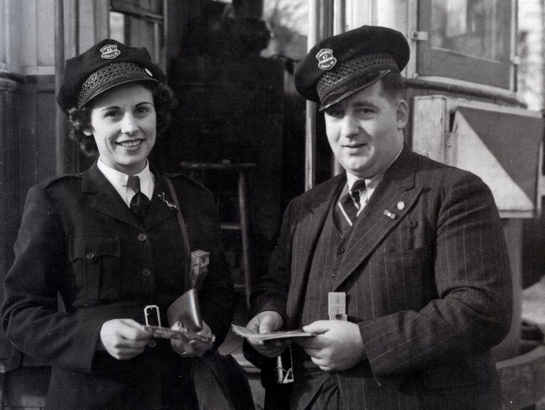
Women, war, and an emergency job

When men went to fight in the Second World War, Edmonton women broke into traditionally male-dominated fields like dairy-delivery, bricklaying, railroading, and policing. Two-hundred women enrolled in the first mechanics class offered by Dominion Motors, and some 1,000 others went on to work with Aircraft Repair Ltd., who assembled and repaired craft as part of the British Commonwealth Air Training Plan.

For Edmontonians, the contemporary notoriety of all these new employment streams paled in comparison to one; the Conductorette. With gasoline and rubber rationed, Edmontonians turned to the city’s streetcar system for transportation, and by 1943 it handled an average of 22,500,000 passengers annually. The boom, wholly unexpected by transit officials, ironically became an unwelcome windfall with a manpower shortage the most pressing issue facing the system.

October 4, 1943, marked the official debut of conductorette service in Edmonton, with forty female employees. By January 1944, Edmonton’s Street Railway Department had fifty-nine female conductors on its payroll. Superintendent Ferrier relayed his pleasure “with the way the conductorettes are doing their emergency job,” but continually emphasized that their role was just that - emergency.

As it became clear the war was ending, the conductorette service began to be phased out. In August 1945, the Street Railway Department terminated the conductorette program and sent home their last four female employees. Despite their personal successes, and despite the public’s infatuation with their “lady conductors,” Edmonton Transit forbid women to serve in any meaningful, public-fronting role for another three decades.

In the words of a 1967 Edmonton Journal article, officials believed that “It wouldn’t be fair to the fair sex to let them drive anything heavier than a family car.” Only in May 1975 did Kathleen Andrews, a British-born, Edmonton-raised transit clerk, break through ETS’ glass ceiling and became the city’s first female bus driver. https://www.forgottenedmonton.com/blog/the-conductorettes

Why the magpie should be Edmonton’s official bird

Ivan writes, “I really like the idea of having an Edmonton Bird and I think the magpie is a decent choice. However, I would choose the raven. It has many of the magpie's characteristics, and a few more. At times when they're just riding the thermals, ravens remind me of eagles. They are also an important part of Indigenous culture, as is the magpie. This comes down to personal taste. I like magpies, but I love ravens.”

What is this

Margriet asks “On the single-track trail below Keillor Road is this brick structure. I always wonder what it was! Perhaps one of your readers can enlighten me.”

Pillars of the Community by Layla Folkmann & Lacey Jane Wilburn, LRT vent close to Rogers Place Arena

https://www.edmontonarts.ca/public-art/pillars-of-the-community

Comment or Contributions

Please note articles may not reflect the position of NSRVCS. River Valley News is meant to be a clearinghouse for the variety of opinions and ideas about Edmonton’s River Valley.

Email river valley photos, event information, comments, or questions to nsrivervalley@gmail.com